Powered By Blogger
Showing posts with label Travel. Show all posts

Tuesday, July 5, 2011

Paradise Beach Lombok Indonesian Travel World


Paradise Beach Lombok Indonesian Travel World
Paradise Beach. Lombok is an island in West Nusa Tenggara. Lombok has beautiful beaches that are not inferior to Bali. Perhaps even more beautiful beach in Lombok from the beach in Bali. Not only Senggigi Lombok, Gili water, Trawangan Gili, gili meno or. One of the fascinating beach is Pante Sorge (Paradise Beach).

Paradise beach in the southern region of East Lombok Jerowaru precisely, about 50km from the city Selong. This beach is known for having beautiful scenery and sandy beaches are clean and white, it is no wonder this beach called Paradise beach.

As the name implies, Paradise beach, a tourist attraction unspoiled beaches. Because not many tourists know its location. Trips to the beach which is located in the Gulf Ekas, East Lombok, West Nusa Tenggara can be a trigger spirit. Towards Paradise Beach need not struggle a bit, because the path to it is difficult to take. The roads are many cavities, broken, and muddy in the rainy season.

When I got there, tired and weary will pay off with beautiful beaches lost Heaven. Do not imagine palm trees and the breeze alone, lapping waves were too fierce. As well as having a strong wind. However, the beach is being looked into by the surfers who are looking alleys and hills to ride the waves. Most tourists who come here are foreign tourists. They hire big cars to get through the damaged roads. The atmosphere of these attractions was calm, quiet, natural, no hawkers who offer goods on tourists. There was only the roar of the waves and bird sounds great-grandchildren shouted.

Monday, June 6, 2011

Cool Colored Fields of Yunnan Best Travel


Cool Colored Fields of Yunnan Best Travel
Yunnan Dongchuan, Longji, Guizhou Province, northwest just beyond the Great Wall and other places into the most beautiful season of the year, where China has the most spectacular scenery in June - Red Land Dongchuan, Yunnan, Guangxi Dragon's Back terraced clouds, Guizhou Libo Church Hill differences of water, northwest of the prairie flowers of cattle and sheep groups, birds in Qinghai Lake vibrant.

These shots of the Yunnan Province of South-Western China give you a taste of the country's rolling fields, the antithesis of the big city China we're accustomed to seeing. Yunnan Dongchuan colorful red land and fields, like a fresh and eye-catching, simple nature of the painting; Guizhou Libo that changes the landscape beauty, people forget the June heat and enjoy cool and comfortable; to living in the southern grasslands of Inner Mongolia Hulunbeier you to experience a different kind of summer.

Another—a multiple-origin model—proposes that these two major rice types were domesticated separately and in different parts of Asia. The multiple-origin model has gained currency in recent years as biologists have observed significant genetic differences between indica and japonica, and several studies examining the evolutionary relationships among rice varieties supported more than domestication in both India and China.

Crescent Moon Lake Oasis Best Travel World


Crescent Moon Lake Oasis Best Travel World
Crescent Moon Spring is 6km south of Dunhuang in the Singing Sands Mountains and is quite literally an oasis in the desert. The Spring's name derives from the crescent moon shape the small pool of spring water has taken between two large sand dunes. Although the area is very dry, the pool doesn't dry up as one might expect.

The Singing Sand Mountains are famous for the sounds the wind makes when blowing over the dunes. Also, the sand is said to be rather noisy when tread upon. The dunes are also famous for their size, some reaching 100m or more, relatively stable despite the fact that the dunes beyond the mountains shift frequently. Also, the sands are said to regain form overnight if tread upon the day before.

Legend says that the Crescent Moon Spring came to existence after a conflict on a night between the Sand Immortal and the White Cloud Fairy, who won the fight with the help of Chang'e from heaven and the bright moon. After the dust settled, the moon became to the Crescent Moon Spring, and the roars of the Sand Immortal became the echo of the sand on Mingsha Mountain. Crescent Moon Spring has been endangered by the sand storms for hundreds of years. It was measured as 4 to 5 meters in depth in 1960, but the average depth was only about 0.9 meter in early 1990. Yet it's still full of rippling water. Indeed, it's one of the wonders in this remote area.

Valley of Flowers in India Best Travel World


Valley of Flowers in India Best Travel World
Valley of Flowers National Park is an Indian national park, Nestled high in West Himalaya, is renowned for its meadows of endemic alpine flowers and outstanding natural beauty. It is located in Uttarakhand state. This richly diverse area is also home to rare and endangered animals, including the Asiatic black bear, snow leopard, brown bear and blue sheep. The gentle landscape of the Valley of Flowers National Park complements the rugged mountain wilderness of Nanda Devi National Park to the east. Together they encompass a unique transition zone between the mountain ranges of the Zanskar and Great Himalaya.

Valley of flower is splashed with colour as it bloomed with hundreds different beautiful flowers, taking on various shades of colours as time progressed. Valley was declared a national park in 1982, and now it is a World Heritage Site. The locals, of course, always knew of the existence of the valley, and believed that it was inhabited by fairies.

While trekking towards valley of flowers, one can experience the beauty of shining peaks fully covered with snow. One can also see the beautiful view of surrounding greenery and various running streams with crystal clear water. The valley is home to many celebrated flowers like the Brahmakamal, the Blue Poppy and the Cobra Lily. It is a much sought after haunt for flower-lovers, botanists and of course trekkers, for whom a sufficient excuse to embark on a mission to reach a place, is that it exists.

Friday, February 4, 2011

White Crater Best Travel World


When you're visiting the city of Bandung, try to stop by the Ciwidey. Here we will find interesting sights of White crater. There are many things that we can get, for example in Ciwidey numerous garden strawberries. In fact, we can pick their own strawberries that we want to buy. On the way to the crater, we will pass the interesting objects such as old railroad tracks, yellowing rice fields, tea gardens and pine forest. Decent place for our visit.

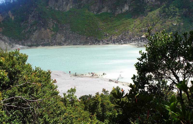
White crater is located on Mount Patuha, a mountain located in West Java. The height of this mountain is 2386 meters. The crater of Mount Patuha is used as an attractive tourist object with the name White crater. Crater in fairly broad. Water color can vary depending on the sunlight. Smoke from the sulfur water sometimes arise that impede our view. The water also cause the smell of sulfur. When the wind is blowing, the smell of sulfur can pierce our noses and make us cough. So, there are several points on this crater is fitted with a warning not to get too close to avoid poisoning sulfur smoke.

The beauty of White crater lake, is very enchanting and amazing. Plus very cool temperatures throughout the day (temperature about 8-22 degrees Celsius). Perhaps because of this crater is located on the mountain which has a height of about 2.434m above sea level. In fact, if you already know the wonders of nature, would say nothing as beautiful as White Crater crater. Because of its natural beauty, White crater is often used as a place Photo prawedding (very much), filming movies and soap operas. Even today in Bandung and its surrounding kota2 also, if one wants to photograph prawedding, white crater will always be the primary choice. The beauty of white crater is difficult to be disclosed by kata2. Come and enjoy yourself dech .. Guaranteed you'll be amazed. There are even some articles about white crater I have ever read on the internet, suppose the beauty of the white crater "Like Heaven scattered"

This crater will give us a different experience. We seemed to be in the snow because the ground is white. Wide crater and bluish-green water that makes us as if were on the beach. The trees are mostly just stayed dry stalks and has helped create a different atmosphere. Here too there are large rocks beautiful. The beauty is what makes this place became a favorite place for the bride and groom to do the wedding photos.

Ijen Crater Best Travel World


Ijen Crater Best Travel World
Lovers of traveling in our trip this time we will invite you to visit tourist areas crater Banyuwangi. To go into the crater, we start the journey from Denpasar-banyuwangi. Mount Ijen Crater is one tourist destination in East Java, which is always crowded domestic and foreign tourists. To go into the crater, will travel across the beauty of protected forests and coffee plantations. Sometimes, along the way to the crater, visible sulfur mine workers were in the vehicle trucks heading to the crater, the journey is very challenging and certainly exhausting. Ijen Crater Finally we arrived at Paltuding region, an area that is a starting point toward the crater.

Spectacular scenery at an altitude of 30.000 ft from the window of the plane left Surabaya-Denpasar gave birth to a question about the location of a green lake tosca at an altitude of 2.000 meters. Lake they will likely be inside the crater of the caldera wall as high as 300-500m. A towering mountain peak located beside it. White smoke billowing from one of the crater were soaring high into the air, making the contrast with the surrounding environment of green jade.

Crater tsb. Ijen crater was called, situated in Banyuwangi, East Java. Spot was never published and well known in France through Adventure Ushuwaia impressions showing the-explorer Nicolai Hulot, sitting on a rubber boat told me about the origins of the lake of Ijen with zero degrees of acidity, has a depth of 200 meters and the volume of nearly 40 million cubic meters, one world's largest crater lake. Acidity is strong enough to dissolve the clothes and fingers. Views bird view camera helicopter was then switched to the edge of the caldera which shows penambang2 crater is struggling to climb carrying tens of kilograms of cargo.

Ijen crater was easy to be visited through Banyuwangi or Bondowoso. The uniqueness of the main crater of the tour apart from the exquisite a view is to see a traditional sulfur mining transported borne by human power. Traditional mining is said to exist only on Indonesia alone (Welirang and Ijen). Expenses are transported each weighing up to 85kg per person. This remarkable heavy burden for most people, when sulfur is transported through the steep caldera wall and 800m down the mountain as far as 3km. Income received by a bearing on average 25 thousand rupiah per day, or about 300 dollars per kilo. A bearer is usually only able to bring down one time every day, because the weight of the job. A few hundred yards there is a round building of ancient relics of the Netherlands said "Irrigation crater", which is now known as the Round Post, an outpost where miners weigh the cargo and get a piece of paper about the content and value.

Travel tour to the crater Ijen, starting from Paltuding 1.600 masl, an outpost at the foot of Mount Merapi Perhutani-Ijen. From here a dirt road continues to climb to an altitude of 2.400 m above sea level and takes about 2 hours leisurely stroll. Along the way many sulfur bearers ran into a friendly exchange greetings. Arrive at the lip of the crater, stunning scenery in front of the eye. A tosca green lake with a diameter of 1 km covered in mist and sulfur fumes were far below. Sulfur-miner miner looks small from the top. To go to the source of sulfur tsb., we need to down the caldera cliff rocks along the path trodden by miners. Wet handkerchief is necessary, because sometimes the wind carried the smoke to the path of decline.

Based crater, parallel to the surface of the lake there are other place of extraction of sulfur. Thick white smoke gushed out from a kind of iron pipe which is connected to a source of sulfur. 600oC molten red hot fumaroles melt out and frozen with cold air, forming a bright yellow solid sulfur. Sometimes uncontrolled burning embers fumaroles, which usually immediately drenched with water to prevent a chain reaction piroporik. Sulfur rocks are cut with a crowbar and transported kedlm basket. In an environment such as breathing. It needed its own struggle, the miners generally worked, biting piece of cloth or cloth gloves as makeshift air filter.

In addition to advance straight to the lake, around the caldera ridge dpt done with more or less takes a full day. Climbing to the crater Ijen generally recommended starting in the morning. For security reasons, the climb to the crater of Paltuding closed after 14:00, because pekatnya smoke and the possibility of wind direction that leads into the path of ascent. To pursue the journey in the morning, visitors are advised to stay at the nearest location Bondowoso, clean mountain town, or in Situbondo a coastal town. If you liked the atmosphere of the mountain plantation, a memorable place to stay is the Guest House Plantation Coffee PTP Nusantara XII in Kalisat, Jampit. This guest house is located inside the housing complex plantation at an altitude of about 1.200 masl. Also available Cottage Tours in Paltuding clean enough, or open the tent at the campsite Paltuding. Temparature average around Ijen crater is 13 o C at noon and 2 o C at night.

To reach the crater Ijen is not too difficult. There are two ways, first through Banyuwangi town 38 km to the west through the slippery, Cashew and continue to Paltuding (1.600 masl). The second way is through the city Bondowoso 70 km towards the east through Wonosari, Sempol (800 masl) continues to Paltuding m. The second way is the most widely traveled people because of the smooth asphalt roads, while the first way through macadam road full of steep grades. Foreign tourists after a visit in Bromo usually come through Bondowoso, continue traveling through Banyuwangi, Bali and Lombok.

Wednesday, December 8, 2010

Jayawijaya Mountain Snow Travel


The Jayawijaya Mountains, formerly known as the Orange Range, are the eastern mountain range of the Maoke Mountains in the central highlands region of the Indonesian part of New Guinea. The range extends for 230 miles east of the Sudirman Range to the Star Mountains. Its highest point is Trikora Peak at 4,750 meters (15,580 feet). The large Grasberg copper and gold mine, operated by the Freeport company based out of the United States, is located in these mountains. The Baliem River has its source in the range. Inhabitants of the range include the Ketengban. In 1997 sightings of animals matching the description of the thylacine, an extinct Australian marsupial were reported from "the Jayawijaya region of Irian Jaya".

Jayawijaya Mountains are a mountain range that extends lengthwise in the centre of the province of West Papua and Papua (Indonesia) to Papua New Guinea Newguinea on. Rows of mountains that has some the highest peak in Indonesia was formed because the appointment of the sea floor thousands of years ago. Although located at an altitude of 4800 mdpl, fossilized sea shells, for example, can be seen on the limestone rocks and contained in klastik Jayawijaya Mountains.

Where we can find snow in Indonesia? Only in Jayawijaya mountain top. Special, snow on snow Jayawijaya unlike in countries that only 4 seasons a few months. Snow in one of the highest peak in Indonesia will be there forever. There are 6 peaks in the mountainous Jayawijaya: Puncak Jaya (formerly Peak Carstenz Pyramid), Peak plans, Northwall Peak, Mula Pulu Peak, Peak Sudirman, and Peak Trikora. Peaks with permanent snow only in the first four peaks. But unfortunately this eternal snow began to melt due to global climate change.

Wednesday, July 28, 2010

Mataram Island West Nusa Tenggara Travel Indonesia


Mataram Island West Nusa Tenggara Travel Indonesia
Mataram is the capital of West Nusa Tenggara Province, Indonesia. Mataram composed of 6 (Six) District of District Ampenan, Cakranegara, Mataram, Pejanggik, Selaparang, Sekarbela, with 50 villages and Environment 297. Mataram is located at 08 ° 33 "- 08 ° 38 'south latitude and 116 ° 04" - 116 ° 10' east longitude. In addition to the provincial capital, Mataram has also become the center of government, education, commerce, industry and services, and is currently being developed to become a tourist city.

The presence of various supporting facilities such as transportation facilities such as the International Airport as the entrance Selaparang Lombok by air, shopping centers, and transportation routes that connect between districts and provinces this is the major consideration in the development of Mataram became a tourist city.

Lombok (population 2,950,105 in 2005) is an island in West Nusa Tenggara province, Indonesia. It is part of the chain of the Lesser Sunda Islands, with the Lombok Strait separating it from Bali to the west and the Alas Strait between it and Sumbawa to the east. It is roughly circular, with a "tail" to the southwest, about 70 km across and a total area of about 4,725 km² (1,825 sq mi). The provincial capital and largest city on the island is Mataram.

In early 2000, religious and ethnic violence (ostensibly provoked by Jemaah Islamiyah Islamist agitators) flared up in the Ampenan area of Mataram and the southern area of Senggigi. Many foreign embassies issued Travel Warnings advising of the potential danger of travelling to Indonesia.

This period of unrest dramatically impacted tourism to Lombok. Tourism has been slow to return to Lombok, provoked in part by a worldwide reluctance to travel because of global tensions. Only since 2008, when most countries lifted their Travel Warnings has tourism recovered to the pre-2000 levels.

Both the local government and many residents recognise that tourism and services related to tourism can potentially be a major source of income to the island. The island's natural beauty and the customary hospitality of its residents make it an obvious tourist destination.

Lombok now appears to be on the verge of a tourist boom. With the commercialisation of Bali over the past decades, and with it the accompanying traffic and reduction in open, natural spaces, many tourists are discovering the charm of 'undiscovered' Lombok. With this new interest comes the development of a number of boutique resorts on the island serving quality food and drinks, but just a stones throw away from rural, unspoiled countryside — much as Bali was decades ago.

Sempu Island Travel Malang East Java


Sempu Island Travel Malang East Java

Sempu Island, is a small island located south of Java Island. The island is located in Malang regency, East Java. Currently Sempu a nature reserve protected by the government. In this island could hardly be found in brackish water.

Geographically, Sempu Island lies between 112 ° 40 '45 "- 112 ° 42' 45" east longitude and 8 ° 27 '24 "- 8 ° 24' 54" south latitude. The island had a total of approximately 877 hectares, bordering the Strait Sempu (Spring Blue) and surrounded on the south side of the Indian Ocean, Eastern and Western.

Sempu Island can be reached from Malang by Blue Spring Beach, and pedestrian use fishing boats, and get licenses.